Featured Image: Gabe Rovick
Over the last few months, we've heard a lot about a potential Super El Niño. No, this isn't a hyperbolic term; it's language describing a "very strong" El Niño cycle, in which Pacific Ocean temperatures rise by more than two degrees Celsius above average.
The latest El Niño Southern Oscillation (ENSO) Diagnostic Discussion issued by NOAA's Climate Prediction Center only bolstered claims of an extreme El Niño cycle setting in, as the latest Pacific Ocean temperature measurements put the odds of El Niño emergence by May - July at 86%, with that number climbing to 92% by December.
"The equatorial subsurface temperature index (average from 180°-100°W) increased for the sixth consecutive month, with widespread, significantly above-average subsurface temperatures across the equatorial Pacific," the report read. Not only have temperatures increased, but our friends at NOAA have measured temperatures nearly six degrees Celsius above average in the last month.
For reference, consider that El Niño and La Niña are defined by deviations of just ±0.5 °C, respectively. Jumps of six degrees are violent events, and the effects of these spikes are not confined to the ocean in which they occur. The last time a La Niña event of this magnitude occurred on record was in 1876. This pattern coincided with extreme flooding, followed by drought and one of the largest famines in recent history.
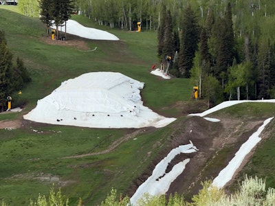
Obviously, the food supply was a little more volatile over 120 years ago, and it would be foolish to assume the same fate awaits us today. However, in an American West that is currently engulfed in severe drought, we certainly don't have much wiggle room.
There's a chance El Niño brings more extreme rains to parts of Colorado and Utah in the fall, which would be a welcome surprise, but there's no guarantee that the blast of moisture would be prolonged. Notably, NOAA concluded its recent May update by stating, "The strongest El Niño events in the historical record are characterized by significant ocean-atmosphere coupling through the summer, and it remains to be seen whether this occurs in 2026. Stronger El Niño events do not ensure strong impacts; they can only make certain impacts more likely."
As skiers and humans who depend on water for survival, we'll be keeping a keen eye on this forecast as it progresses throughout summer 2026.