AS SEEN IN THE 2012 FREESKIER BACKCOUNTRY EDITION. ILLUSTRATION: NIKKI ARCIERI.
MORE IN THIS SERIES:
• PART I: THERE'S NO END TO THE LEARNING PROCESS
• PART III: AVALANCHE BURIALS AND SEARCHING TIPS
• PART IV: DIGGING PITS AND WARNING SIGNS
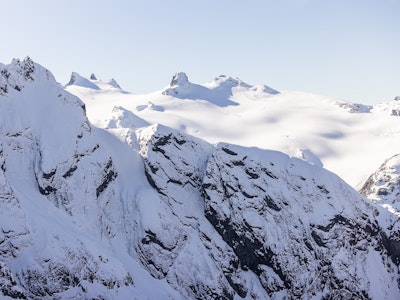
SLAB AVALANCHE: A slide with defined boundaries including a crown, flanks, stauchwall and bed surface.
WET/LOOSE SLAB: A warm temperature wet-snow sluff originating in the rocks.
LOOSE AVALANCHE: A point release or a sluff in dry snow, often created by a skier when the surface snow is unstable on slopes steeper than 40 degees.
AVY PATH: A recognizable avalanche track indicated by flagged trees, couloirs, or open faces at least 30 degrees.
RIDGE: If possible, put your up-track where you can view your descent, so you can observe, test the snow and make a decision about its stability.
CLIFF BAND: Rocks radiate heat and create a temperature gradient in the snowpack that develops facets or depth hoar.
WINDROLL/POCKET: Pay attention to micro terrain features such as convexities or rollovers—there may be rocks underneath. These facet gardens could allow for a localized collapse which could propagate to other parts of the slope.
TIMBERED SLOPE: Forested slopes can slide. It all depends on slope angle. The only safe trees are those that are too tight to ski through. Watch for flagged trees (trees with broken branches) for signs of previous avalanche events.
• PART I: THERE'S NO END TO THE LEARNING PROCESS
• PART III: AVALANCHE BURIALS AND SEARCHING TIPS
• PART IV: DIGGING PITS AND WARNING SIGNS